


Geoglyphs and worldwide geometrical
symbols
Lines over Europe
All
just
a
game?
Did
Mr.
Karl
Bedal
simply
draw
a
few
lines
on
a
map
and
some
places
just
happened
to
lie
underneath?
Definitely
not.
The
straight
lines
and
identical
distances
mean
that
any
coincidence
is
absurd.
What
Mr.
Bedal
(and
others)
discovered
in
Germany
was
found
by
Monsieur
Xavier
Guichard
in
the
same
way
in
France.
Our
Mr.
Guichard
first
held
office
as
the
chief
of
police
in
Paris,
then
studied
philology,
advanced
to
become
the
vice
president
of
the
French
Society
for
Prehistory,
and
began
to
ask
him
self
how
many
places
there
might
be
in
France
with
the
same
root
word
in
their
name.
So
he
started
searching
for
places
containing
the
word
"Bourg,"
others
with
the
root
words
"Flora"
or
"Calais."
At
the
word
"Alaise,"
his
heart
began
to
beat
faster.
Believe
it
or
not,
382
place
names
contained
the
same
root
word,
and
a
further
47
places
went
back
to
"Calais."
That
could
no
longer
be
described
as
normal.
Monsieur
Guichard
reached
for
a
ruler
and
map.
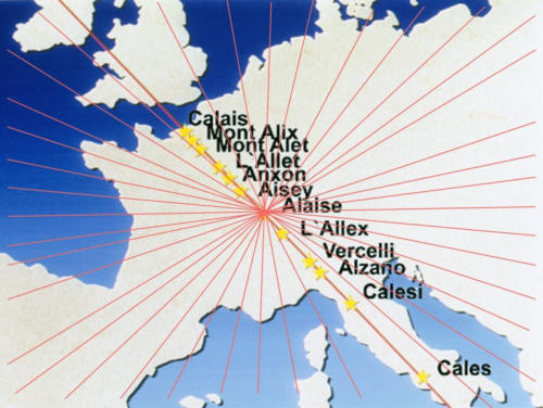
Many
of
the
places
lay
under
a
straight
line
from
the
British
Isles
over
the
Alps
to
Sicily:
Calais-Mont
Alix-Mont
Alet
-
L'Alet
-
Anxon
-
Aisey-
Alaise-
L'Alex-
Alzano-Calesi-
Cales,
and
so
on.
Here
24
lines
from
all
points
of
the
compass
crossed
at
the
village
of
Alaise.
This
place
lies
in
the
eastern
Jura,
northeast
of
Salin-les-Bains,
just
70
kilometers
away
from
the
Swiss
border
-
actually
in
the
heart
of
Europe.
The
24
lines
that
cross
here
run
from
Scotland
to
Corsica,
from
Great
Britain
to
France,
from
Portugal
to
Germany.
More
and
more
parallel
lines
appeared.
One
of
them
intersected
Carlisle
and
Ely
in
England,
Calais
and
eight
further
names
derived
from
Alaise
in
France,
and
went
via
Alasio
and
Calice
in
Italy
to
Alasio
on
Corsica.
Xavier
Guichard
originally
thought
that
the
whole
system
of
lines
was
based
on
the
old
"wind
rose
system."
Before
longitude
and
latitude
were
introduced,
maps
were
made
in
accordance
with
the
"wind
rose
system."
A
point
was
fixed,
usually
on
a
hill
top,
and
lines
were
drawn
from
there
in
various
directions.
Someone
then
rode
along
those
lines
to
measure
the
length
of
the
ride
from
one
point
to
the
next.
Cross-
connections
between
the
lines
were
also
possible.
But
Guichard
soon
noticed
that
many
lines
had
to
be
older
than
any
wind
rose
system.
Frequently
the
points
were
not
just
the
same
distance
from
one
another,
they
also
touched
on
places
which
were
unknown
in
the
early
Middle
Ages-for
example,
a
Stone
Age
settlement
under
the
waters
of
Lake
Zurich
near
the
town
of
Meilen.
Rotten
poles,
bones,
ceramics,
and
stone
from
a
settlement
thousands
of
years
old
were
found
there
in
the
winter
of
1854.
Xavier
Guichard's
line
went
precisely
over
it.
Furthermore,
the
wind
rose
system
could
not
explain
lines
from
England
to
Sicily.
The
linear
distance
is
about
2,000
kilometers.
And
the
prehistoric
holy
sites
with
the common root words-L'Allet, Alaise, L'Allex,
and
so
on
-
existed
long
before
the
wind
rose
system
was
introduced.
The
philologist
Guichard
could
not
contain
his
surprise
and
noted,
"There
must
at
some
point
have
existed
a
homogenous
civilisation
which
was
based
on
considerable
scientific
knowledge."
Incidentally,
the
village
of
Alaise,
where
all
the
lines
intersect,
was
a
druid
holy
site
as
late
as
Roman
times.
In
47
BC,
Julius
Caesar
defeated
the
Gallic
tribes
under
Vercingetorix.
(The
latter
even
appears
in
Asterix.)
The
druids
were
clearly
aware
of
the
sacred
nature
of
this "star point of Alaise."
Read more:
Remnants
of
the
Gods, page 137


Geoglyphs and
worldwide geometrical
symbols
Lines over Europe
All
just
a
game?
Did
Mr.
Karl
Bedal
simply
draw
a
few
lines
on
a
map
and
some
places
just
happened
to
lie
underneath?
Definitely
not.
The
straight
lines
and
identical
distances
mean
that
any
coincidence
is
absurd.
What
Mr.
Bedal
(and
others)
discovered
in
Germany
was
found
by
Monsieur
Xavier
Guichard
in
the
same
way
in
France.
Our
Mr.
Guichard
first
held
office
as
the
chief
of
police
in
Paris,
then
studied
philology,
advanced
to
become
the
vice
president
of
the
French
Society
for
Prehistory,
and
began
to
ask
him
self
how
many
places
there
might
be
in
France
with
the
same
root
word
in
their
name.
So
he
started
searching
for
places
containing
the
word
"Bourg,"
others
with
the
root
words
"Flora"
or
"Calais."
At
the
word
"Alaise,"
his
heart
began
to
beat
faster.
Believe
it
or
not,
382
place
names
contained
the
same
root
word,
and
a
further
47
places
went
back
to
"Calais."
That
could
no
longer
be
described
as
normal.
Monsieur
Guichard
reached
for
a
ruler
and
map.
Many
of
the
places
lay
under
a
straight
line
from
the
British
Isles
over
the
Alps
to
Sicily:
Calais-Mont
Alix-Mont
Alet
-
L'Alet
-
Anxon
-
Aisey-
Alaise-
L'Alex-
Alzano-
Calesi-
Cales,
and
so
on.
Here
24
lines
from
all
points
of
the
compass
crossed
at
the
village
of
Alaise.
This
place
lies
in
the
eastern
Jura,
northeast
of
Salin-les-Bains,
just
70
kilometers
away
from
the
Swiss
border
-
actually
in
the
heart
of
Europe.
The
24
lines
that
cross
here
run
from
Scotland
to
Corsica,
from
Great
Britain
to
France,
from
Portugal
to
Germany.
More
and
more
parallel
lines
appeared.
One
of
them
intersected
Carlisle
and
Ely
in
England,
Calais
and
eight
further
names
derived
from
Alaise
in
France,
and
went
via
Alasio
and
Calice
in
Italy
to
Alasio
on
Corsica.
Xavier
Guichard
originally
thought
that
the
whole
system
of
lines
was
based
on
the
old
"wind
rose
system."
Before
longitude
and
latitude
were
introduced,
maps
were
made
in
accordance
with
the
"wind
rose
system."
A
point
was
fixed,
usually
on
a
hill
top,
and
lines
were
drawn
from
there
in
various
directions.
Someone
then
rode
along
those
lines
to
measure
the
length
of
the
ride
from
one
point
to
the
next.
Cross-connections
between
the
lines
were
also
possible.
But
Guichard
soon
noticed
that
many
lines
had
to
be
older
than
any
wind
rose
system.
Frequently
the
points
were
not
just
the
same
distance
from
one
another,
they
also
touched
on
places
which
were
unknown
in
the
early
Middle
Ages-for
example,
a
Stone
Age
settlement
under
the
waters
of
Lake
Zurich
near
the
town
of
Meilen.
Rotten
poles,
bones,
ceramics,
and
stone
from
a
settlement
thousands
of
years
old
were
found
there
in
the
winter
of
1854.
Xavier
Guichard's
line
went
precisely
over
it.
Furthermore,
the
wind
rose
system
could
not
explain
lines
from
England
to
Sicily.
The
linear
distance
is
about
2,000
kilometers.
And
the
prehistoric
holy
sites
with
the
common root words-L'Allet, Alaise, L'Allex,
and
so
on
-
existed
long
before
the
wind
rose
system
was
introduced.
The
philologist
Guichard
could
not
contain
his
surprise
and
noted,
"There
must
at
some
point
have
existed
a
homogenous
civilisation
which
was
based
on
considerable
scientific knowledge."
Incidentally,
the
village
of
Alaise,
where
all
the
lines
intersect,
was
a
druid
holy
site
as
late
as
Roman
times.
In
47
BC,
Julius
Caesar
defeated
the
Gallic
tribes
under
Vercingetorix.
(The
latter
even
appears
in
Asterix.)
The
druids
were
clearly
aware
of
the
sacred nature of this "star point of Alaise."
Read more:
Remnants
of
the
Gods,
page 137